This will be a long installment as we have been out of computer service for some time now. So grab a cup of coffee, settle in and read it...and leave comments! We LOVE comments. This is the exciting story of Scott and Sue finally leaving the country!
Part I - Hurry up and STOP!
Anybody who’s been reading this blog for a bit knows that the captain tends to get just a little (his head blows up) antsy after staying in one spot too long. After nearly a month in Marathon (Don’t miss the Overseas Lounge!) I was really ready to go and even more excited to actually start looking for a good day to jump of to the Bahamas.
On Saturday 2/10, we said goodbye to our friends Joe and Peg, weighed anchor, took on fuel, water, and gas and headed up the keys for an anchorage called Channel 5. We’ve been there before and it is a little 25 mile run from Marathon. OK, we were a little rusty...forgot to undo the reefing lines before trying to raise the sail, misinterpreted the GPS and thought we were nearly aground, then nearly went aground due to bad piloting. Sheesh! Finally we got out a ways and turned to the east. We set the sails and kept the engine on for a while to charge batteries and keep our speed up. It was a beautiful sail. We pure sailed for about an hour in the middle of the run and then back to motor sailing when our speed got below 4 knots and stayed there.
We found our way easily into Channel 5 (last time there were some near misses as we got too close to the shoals on the east side). We anchored where we had before, a couple miles east of the bridge amongst a nest of crab pots. Nice. Somehow being on the move changes everything. Same boat. Same us but somehow different as well. And, VERY different from the ‘cozy’ anchorage in Boot Key...we’re the only boat here! The bad part about the anchorage is that it is wide open to the north and that’s where the wind is from but it is pretty light and we’re not worried. We began to worry around midnight with the wind shrieking through the rigging and the boat rocking up and down on 3 foot waves. Anchor didn’t drag but not much sleep that night.
On Sunday, 2/11, we decide to stay so as to maybe leave for Bahamas right from here. It is about an 80 mile shot from here to Riding Rocks at which point you can simply enter the Great Bahama Bank and continue east toward the North West Channel and Nassau. Although it is farther from here to the Bahamas the northerly push we will get from the Gulf stream should moderate that somewhat and allow us to make good time. Monday might have winds clocking to the south-east so that would be perfect. We’d leave around noon, sail through the night and arrive at Riding Rocks around 0800. Could work...now just keep an eye on the weather!
As we had gotten little sleep Saturday night I stole some time to take a nap. While dozing I heard someone holler something about Chicago and then heard Sue say, “ART! What are YOU doing here”? I went topsides and sure enough there was good old Art from Stem to Stern Yacht Care in Fort Lauderdale. He was fishing with a buddy and saw Enee Marie and said, “ I know that boat”. Nice and weird to see him here in the middle of nowhere!
As I was listening to the off shore report in the afternoon Sue came down the companionway and said those words you don’t like to hear, “We’re dragging”! Sure enough the wind had shifted to the east and while that gave us better protection and smaller waves it also twisted our anchor completely around and out of the dirt. We started the engine and I went to the bow to tend to the anchor. I put my hand on the snubber and I could feel the anchor dragging along the bottom. Suddenly it pulled tight and jerked the boat about. The anchor had re-set itself. Thank you! We’re not where we were but we’re still clear of most of the crab pots so we decide to do nothing.
It was a wonderful night. Very calm and crystal clear and we took advantage and caught up on the sleep we missed the night before. Maybe tomorrow we head to the Bahamas. . .
2/12 Monday - No. A line of thunderstorms came through our anchorage starting about 0700 and rained and blew and lightning and thundered and threatened water spouts for the next 5-6 hours. It rained 8 inches on Long Key very near us. This is tedious. There is nothing to do really except to watch our position to see if we are dragging and to wet our pants if we feel our hair stand up on end! A tense morning made more so by the way NOAA gives locations of things. For some reason everything is relative to ‘Craig Key’. Sue and I poured over our charts and guidebooks and could not find ‘Craig Key’. It was infuriating - “. . . a line of thunderstorms some with waterspouts as big as Jupiter have been sighted 3 miles from Craig Key. . . “ Are we near that or not! I called friends back in Marathon but they were not around. I called my brother-in-law up in Indiana and put him on an internet search for Craig Key. He called back a little later and said it was right between Fiesta Key and Long Key and was really tiny. We look at the charts again...let’s see, Fiesta Key. Got it. Long Key.....got it...HEY! We are anchored about 1 mile off of, you guessed it, CRAIG KEY.
WHO KNEW!?
Some navigator!
It is Monday afternoon now and the rain is finally stopping along with the wind. We filled two 5 gallon buckets with fresh water just by putting them out on deck. Oh, and there’s about 100 more gallons in the dingy which we were towing for a change to maybe clean her bottom a little. Well, maybe we’ll put some soap in the dingy and call it a washing machine and rinse in the buckets. (I wonder if I could lower the outboard into the dingy and start it up to provide some agitation? Hmmm...better not!)
We may have a weather window for the Bahamas tomorrow. Wind is supposed to be south east going south and then south going south-west and west on Wednesday. That would be perfect. It is more a matter of what is the weather that we will be heading into when we get there and we are trying to get as much of that information as we can before we take off. No sense going on a 20 hour sail just to get your butt kicked at the other end!
2/13 Tuesday - While everything was not going on we had Leah sign us up with the Caribbean Weather Service. This is an SSB deal that is run by a guy named Chris Parker and it is WORTH it. He comes on the air at 0640 every morning with a general weather report for the Bahamas. After that boats can call him on their SSB and ask for specific weather for their next intended sail. He spends about 10 minutes with each caller giving very detailed predictions of wind and waves. Well, we called him this morning and he recommended that we wait one more day as there were still some squalls around in the gulf stream and a pretty stiff west wind when we would approach the banks which can make the transition from 2000 foot deep water to 15 feet deep water a little exciting. So . . . one more day on the anchor. We did little except read. The boat is ready to go and so are the crew. One more day. . .
Part II - Actually Sailing Stuff
 Wednesday 2/14. We call Chris in the morning and he thinks this will be a great day to cross and no problem with the night sail. Wheeeee....We make final preparations which is easy as we don’t want to leave until around noon which should provide for an early morning arrival at Riding Rock. Only 92 miles!
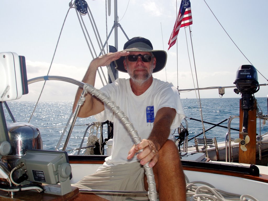
Alligator Reef light at left
At 1130 I couldn’t stand it anymore and we weighed anchor. What a baby! It’s a beautiful day but very light winds. We get the main up right away and motor out under the Channel 5 bridge. After clearing the shoals we set a course for Alligator reef. From there we’ll make a slight course correction for Riding Rocks. The wind is almost dead behind us and very light. Yeah....inflated and deflated genny. Still we’re getting some push from the sails even though they do a lot of flapping. We keep them up. It’s a SAILBOAT damn-it! We are on course and making 5+ knots with a little help from the engine. So GREAT to be on the open ocean. When we pass Alligator shoal light the bottom drops out from under us. The depth sounder goes from 20 feet to 100 feet in about 20 seconds. Bahamas here we come!
 And a beautiful night sail ensued. We sailed much of the 90 miles and motor sailed the rest. For many hours we went wing and wing making 6+ knots. What a great evening. Except for the freighter. As we all know running lights can get confusing late at night when you’re tired. And anyway, who can remember green is starboard and red is port? Lights have no distance and you never can actually make out the shape of the ship to get its line as to which direction it is actually heading. Sue was at the helm and asked for help in passing the approaching freighter. It seemed far away and heading south. We could see it’s green running light which would be the STARBOARD one right, Scott? At first it seemed we could pass easily in front of it but then Sue looked at the radar again and said, “hey, this guy is CLOSE”. (note to you young sailors out there: If you can hear his engines he is VERY close.) OK, pass green to green but ...green...starboard...port wine, red, green, I’m tired...mommy! We drove around in a figure 8 pattern in front of the oncoming freighter trying to get our bearings. He (yeah, like these guys look out the window ever) must have thought we were playing some sort of game of marine chicken. Finally, Sue said, “THIS WAY” and we did manage to pass green to green by about 100 yards! Not much sleeping after that...too busy cleaning underwear!
2/15 - Thursday - The rest of the night was uneventful. Crossing the gulf stream is an old physics teachers dream come true (well, one of them...). Once we were totally into it (about 20 miles off shore) we had a heading of around 110o Magnetic and a course over the ground of around 75oM. How’s that for relative motion! We didn’t totally shake the effects of the stream until about 5 miles off the Bahama Banks.
It was at about this point that Sue said, “You know the depth meter is stuck at 74 feet”. I turned it off and on again (isn’t this how we fix everything now...reboot!) Now it went to 0.0 feet. Great. We are about to enter a realm where the very deepest part is about 15 feet and we show up with no depth sounder. The other one wasn’t working either. Hold on...two things don’t break at once. I checked the chart for our current location. OK! The water here is about 2400 feet deep! No bottom as far as the sounders are concerned. When we got on the bank they worked fine.
Quite a moment for us. We successfully crossed the gulf stream and sailed most of it. Now we were in our first foreign land (Finally! Thanks for your patience!) We passed the rocks that are named South Riding Rocks and entered crystal clear water about 15-20 feet deep. From here it is a 42 mile shot straight across this Great Bank to a place called Northwest Channel. Here the ‘Tongue of the Ocean’ meets the bank from the east and it is these waters that connect you to Nassau. So, now what?
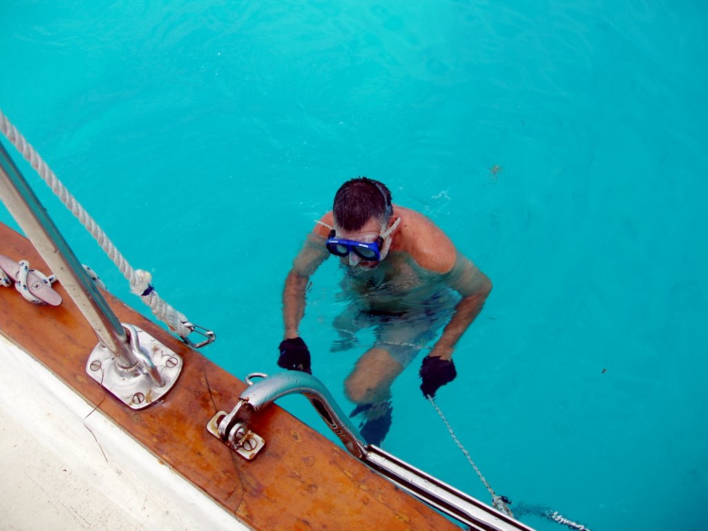 Well, first of all, it seemed the boat was going slower than it should for the number of RPMs we were running (there was NO wind now). After about 10 miles of motoring/sailing we dropped the hook and I dove down to look at keel/propellar to see if we were dragging anything. Nothing there. I scraped off a few more barnacles off the prop while I was there. What I did notice was there was a significant current dragging me backwards which probably explains why our speed over ground seemed to be too slow. (Our knot meter is broken which would show our speed with respect to the water. With that I could have saved a swim. )
So, go on? Stop? Where to now? Our original plan was to continue on and anchor on the Bank at the other end and then head for an anchorage tomorrow. We talked with Chris Parker the weather master in the morning and he suggested taking a rest and putting in another night sail to make Nassau the next day. No wind he told us until after midnight anyway. Staying put for a few hours sounded good to us so we took naps and relaxed the afternoon away.
Now, about this great Bahama Bank. Understand there is nothing here. Nothing. Pure horizon 360 degrees. The water is amazingly clear and flat. It reminded me of one of those calm summer days on Lake Michigan. . . without the flies. When we dropped the anchor I watched it go all the way down in 15 feet of water like it was right there on the deck. Sue saw a dolphin swim to the surface and down to the bottom again without taking a picture (Sue didn’t take the picture not the dolphin..ok, neither Sue nor the dolphin took a picture. Syntax police are going to fine this.) She has to pick up the pace. We see NO other boats. I am surprised. For all the talk of coming and going to the Bahamas I expected to see some other sailboats. Nope. Just us as far as the eye can see.
So back on it at 1600 hours. Hope to make Nassau in about 20 hours putting us in around noon. We’ll try for a slip at one of the marinas as the weather is supposed to get very windy Saturday and Sunday. Onward!
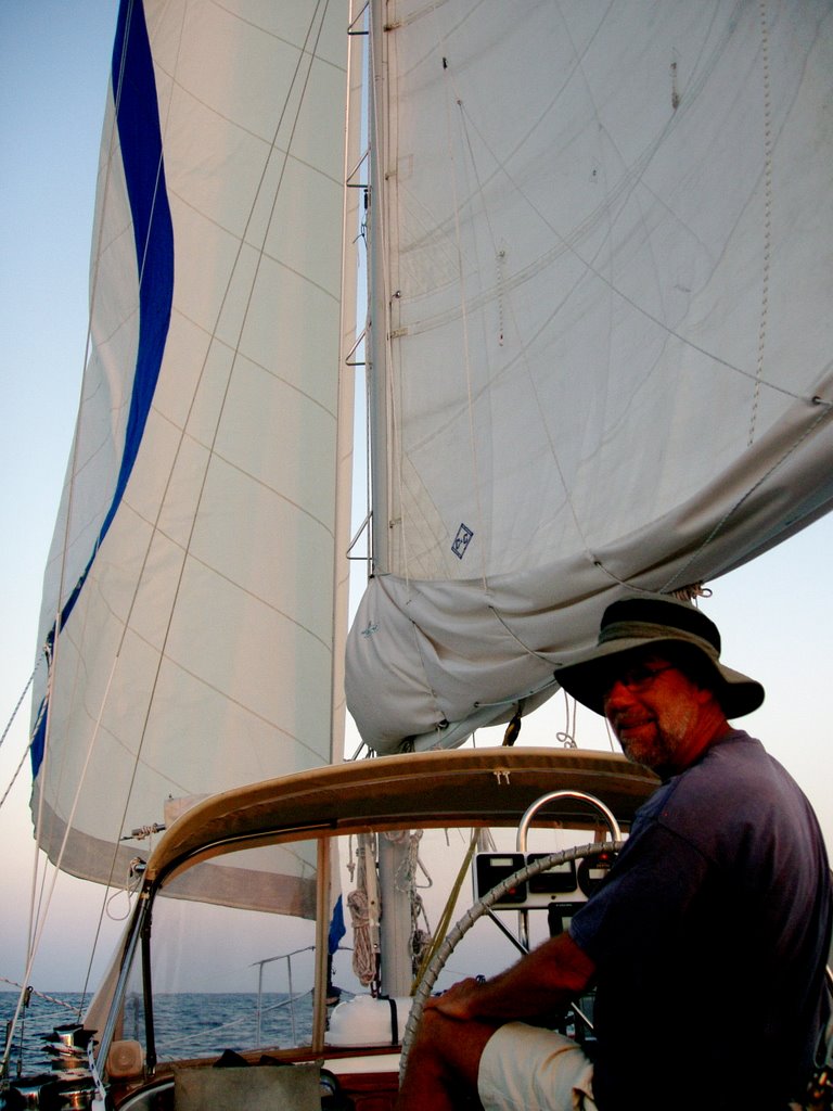
No wind when we left our ‘anchorage’ but we motored along slowly and marveled once again at the water and the fact we are the only boat...apparently on the entire planet of WaterWorld! In the early evening we were able to start motor sailing and then pure sailing and it was perfect. Except for the unexpected brown/black streak of water ahead. It was about 2 hours until sunset and the sun was behind some clouds when we noticed this dark patch ahead. The depth was a consistent 15 feet at least and the charts showed no markings of anything less. What is that stuff? Sue looked through the binoculars and could tell that it wasn’t grass floating on top. It was something below. Do we go ahead and sail over it believing our charts? Sue says NO! We tacked and sailed by it seeing rocks/coral below. Yikes! Now what. We notice several more dark streaks ahead. We can’t tack through all of them. As we come to the next coral/rock place we hold our breath and easily cruise over. Whew! Maybe we’ve been sailing over these rocks all day and just now noticed them because of the late day lighting. Hmmmm. Anyway now we do trust our charts and continue on. The rest of the evening had just enough wind to keep us going 4.5 - 5 knots on flat seas. Not much to do at the wheel except nudge it a little every once in a while. I could lean back against the main sheet and enjoy. Stars came out full force too and I remembered once again why I got into this retirement business. Sue made a tasty pasta dish and we dined under the stars with the water sliding under the keel. Best waterfront restaurant on the banks! What a night!
We made our way to Russell Beacon (which doesn’t work - like a lot of the ‘beacons’ down here’. ) and then on to North Channel Light which does work. A little apprehension here as the path around the light is a little narrow and we are going through around midnight. No problem though (Sue was able to keep us right on course which is different that my window of 20o either way from the rumb line!) and we once again step off into crazy deep water called the Tongue of the Ocean. Not much wind anymore as we begin the final 50 mile leg of the journey to Nassau. We’re both really tired and go for 2 hour shifts instead of 3. During my 10 - midnight shift it seemed like there was beginning to be a little wind so I unfurled the genoa (We usually keep the main up and reefed for sailing at night wind or no wind.) and got a little boost in speed. Wind was on our port quarter enough to keep the sail filled. We motor sailed this way most of the night. During Sue’s 4-6 shift she got me up because the wind and seas had risen and now Sue was doing her favorite thing: steering in following seas at night. It IS creepy as you can’t anticipate the waves coming under and twisting the boat. Enee is a very forgiving craft though. Kind of like the big, goofy, easy going kid at school that you just can’t piss off.
Engine off now we sailed hard (YAR!...More CANVAS!) all the way to Nassau. The predicted weather for the weekend is for nearly gale force winds on Sunday so we hope to get into a marina for the weekend and hunker down. Sue stays busy on the radio trying to contact marinas without much luck. The biggest one, which is the one we wanted, was full. She finally made contact with Hurricane Hole Marina (that should work!) and got a slip reserved there.
 Good deal. Outside the entrance to the harbor area you have to officially ask for permission to enter the harbor on VHF channel 16 which we received after spelling ‘ENEE’ a couple of times. The harbor area of Nassau lies between the town of Nassau on New Providence Island and Paradise Island. Cruise ships (5), lots of boat traffic and a reversing current. Not a great place to anchor but lots of boats are.
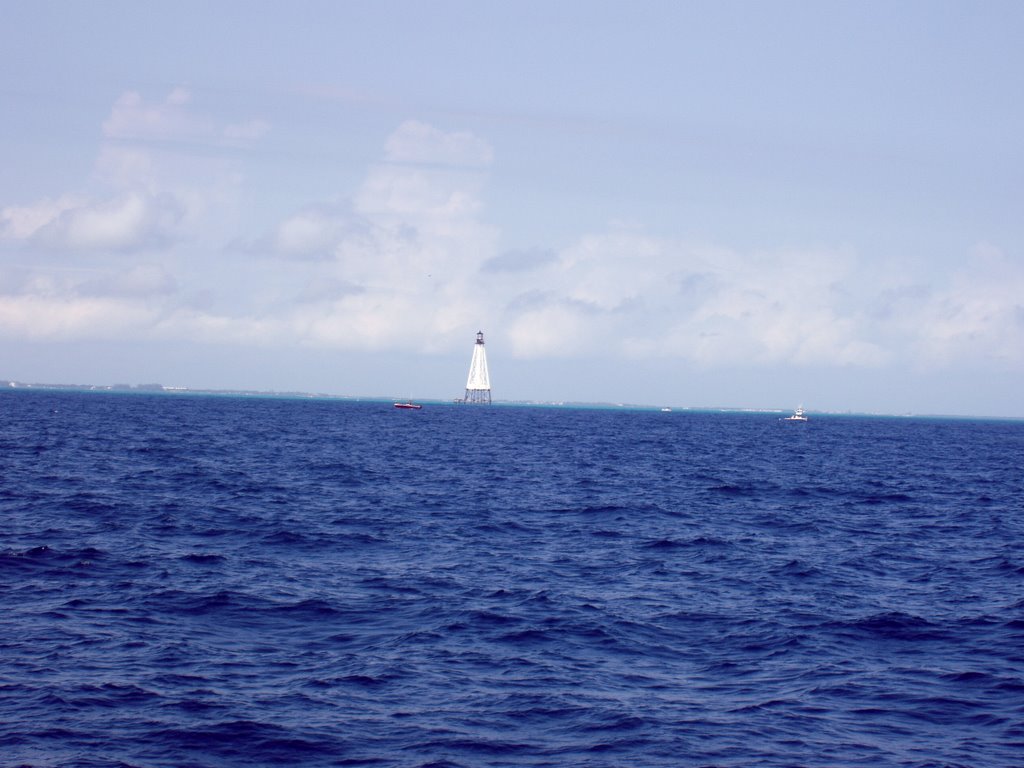
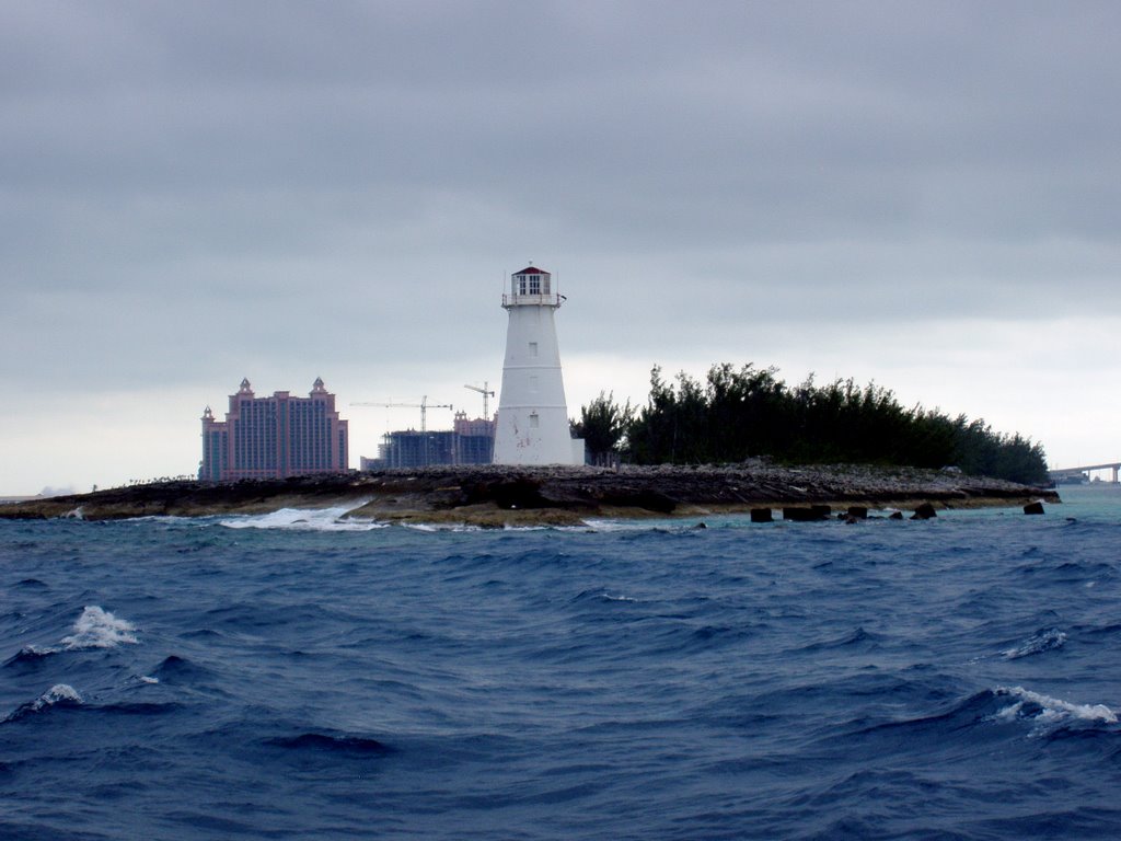
Lighthouse marking Nassau with Atlantis in the background.
There are two 65 foot high bridges very close together that span this waterway and connect Nassau with Paradise Island. Our marina runs the gas dock between the bridges. We are to stop there for fuel and also to receive our customs papers. There is not a lot of room to maneuver between the bridges and the current is running very fast. I pull up as best I can to the face of the gas dock as Sue stands by with the dock lines. I notice a woman slowly get up and come to the dock to get the bow line that Sue throws her. She better hurry as the wind is blowing off the stern but ‘hurry’ is not in this woman’s vocabulary nor is ‘how-to-tie-a-knot’. I tried to encourage her to hurry as the stern is easing farther and farther from the dock. She still seemed puzzled and slightly entertained by her own knot tying efforts. When I was nearly perpendicular to the face I told her to untie me and I’d come around again. She seemed genuinely disappointed and a little insulted. She’d worked so hard on that macramé’ piece she had constructed with my dock line. When we came around again a young man had come down to help and we were in and fine.
It’s funny, when we are on a long run like this I always spend some of the time that I dedicate to worrying that I’d screwed up my calculations and that we would run out of diesel at some critical time. Remember we have no working fuel gauge but have pretty good data that we use 2/3 of a gallon per hour. Still...you’d like to look at a fuel gauge in the middle of the night and see that you have plenty of fuel. So after being ‘on it’ for 48 hours with lots of sailing but lots of motoring as well we used...16 gallons of diesel. We carry 75 gallons! I got to find other things to worry about! World hunger maybe.
We got the boat into the slip with no problem and lots of help from the dock hands. We are so happy! We have finally moved this little adventure up another notch and have cut the thread connecting us to the good old USA. We are also sooooooo tired. Of course we took turns sleeping for the two days but we never slept more than 2 hours at a time and you don’t sleep all that well on the go anyway. We look forward to exploring Nassau a little, a little re-provisioning, a little hunkering down when the front comes through on Sunday. Life is good...good and SHORT!
 Finally, I went to the office to check in and pay for the slip. A very nice lady gave me a very BIG bill. In my tired state I just looked at it the way I used to look a differential equations - puzzlement and awe. Finally I said, “The slip is $2.50/foot, right?”. Wrong. Here’s a little tip boys and girls...either use updated cruising guides or double check the cost before making the deal. Our guide is 3 years old. The slips here are now $4.00 per foot. Yikes. Oh, well...only money. I’ll get more. We dined at the Green Parrot Bar right here at our marina. Cheese Burgers and Kalik beer. Yum. Better than the hard tack and weevil infested biscuits that we eat when we are at sea. Now for some real sleep.
It is Saturday morning now as we post this blog. We’ll post again before we leave for the Northern Exumas on Monday and then as we find other places with internet which I suspect won’t be often.
Above - Enee proudly flying her Bahamian courtesy flag.
Dont forget to COMMENT!
10 comments:
Charles Borden said, "the intimate relationship of an induvidual to his ship-has much to do with happy voyages. Well planned and executed passages are rarely spectacular. Most exciting experiences are the result of error-which of course can happen to anyone. But the spectacular tales are, more often than not, the result of poor planning, inadequate equipment or poor seamanship." Your adventures have been spectacular and they've only just begun. So happy for both of you. Enjoy the Bahamas!!!!
I've been reading daily since the beginning. I can't believe you are finally there. I feel like I've made the trip myself.
Congratulations
Saints Fan
Catalina 30 Solitaire #65
Lake Arthur, LA.
Sadly, Sue's lifelong dream of becoming a camera person on the Calypso while sailing with the Cousteau's will never be fufilled due to her nearly complete inability to film dolphins. I still think that Dolphin picture from an ealier entry was a postcard with the slogan photo-shopped out.
YEAH!!!!
I didn't like the part of almost hitting the other boat, but it sounds like a great trip otherwise. Can't wait to see you in only 3 WEEKS!!!
Alright, I want a piece of this bahamas action.
Questions and comments:
The water here is about 2400 feet deep
So you have nothing under you for 2400 feet...sounds alot like falling off a cliff. I'll pass.
Alliagator Shoal will be my pen name when I either a) become a wrestler or b) become a poet.
Is english the primary language in the Bahamas, or do you have to hail (hale? hayle?) them in spanish?
Aha, I think I finally figured out how to post a comment, only took me a year & a half!
What an adventure! And as for drinking coffee & reading...it's 5:00 somewhere (here) & I had a bloody mary! Glad you are safe, wish I was there! Got 15 feet of white stuff Tues & Wed and a bit more today. Sally
Scott and I have also been following your blog since we moved aboard our boat in Key Largo in December. We are now in Key West and plan to head across the Gulf Stream also in May.
We have been cheering you on for weeks now. Congrats! Can't wait till the next posting!
Annie and Scott
Brown Eyed Girl
Stock Island, Fl
Last Saturday I took an intro to Navigation class up in Waukegan, in preparation for my summer Chesapeake adventure. What I learned in that one day gave me some better insight into what you go through in plotting and following a course, but also a new respect for how intrepid you both are. I missed one question on my test, which had to do with lights on sailboats at night. If figured no big deal, but I bet it would have been if I had been out there where you were and screwed up on my reading of lights on a f--ing freighter and had been run down! Holy Shiite!
Way to go! One year and a half to retirement for me, then I will track you down wherever the hell you are and buy you both dinner and beers!
Bravo...With a few feet of snow and temps in the teens, it's a joy to log on to your site and live vicariously with you through this dam winter. Enjoy your adventures.
Terry
Catalina 30 JAFTICA #6245
Thanks for sharing your adventures - Having a great time browsing your site!
Post a Comment